SCROLL DOWN
Hydrography is defined as “the branch of applied science which deals with the measurement and description of the physical features of the navigable portion of the earth’s surface [seas] and adjoining coastal areas, with special reference to their use for the purpose of navigation or submarine installations.
Hydrographic surveying “looks” into the ocean to see what the sea floor looks like.
SPS Divers are well prepared to perform the best quality videos and photography of our client’s submarine assets. Our team is focused in what our client wants to see.
SPS directs field programs for hydrographic surveys, develops survey specifications, test new technology and improves procedures to increase efficiency in survey data acquisition, data processing, and chart production.
The effects of tides, combined with large amounts of water and waves from storms make coastal areas some of the most at-risk areas for flooding subsequently affect to installed submarine cables or for the future ones. SPS develop coastal maps and flood hazards accurately where many factors must be taken into account, such as the amount of development in the area, the types and strength of storms that historically have affected the area, and onshore and offshore elevations.
Having almost 25 years’ experience on this field, SPS Management personnel come from the bottom of the sea and have a full dedicated life in the Cable Installation and Diving works sector.
A survey image from the sea bottom.
Detailed view of the Sonar Vision showing trench profile.
- Submarine Telecom/Power Cable Route Studies and Surveys for coastal areas (Shore-ends)
- Telecom/Power Cable Corridor Surveys (Findings & Recommendations)
- Telecom/Power Cables & Pipeline Survey Inspections.
- Photo & HD video reporting.
- Coastal Mapping.
- Multi Beam, Sub Bottom, Side Scan Sonar, Magnetometer, Video Survey, Burial Surveys (TSS)
- Debris Surveys.
- Bathymetric Surveys.
- Landfall Topographic Surveys.
- Surveys for construction purposes (marinas, boat landings and near-shore construction)
- Post-dredging and silting surveys for ports.
[/no_unordered_list]
- Telecom/Power Cables & Pipeline Survey Inspections.
- River Surveys including location of utilities.
- Riverside & Canal Mapping.
- Multi Beam, Sub Bottom, Side Scan Sonar, Magnetometer, Video Survey, Burial Surveys (TSS)
- Surveys for construction purposes (marinas, boat landings and near-shore construction)
- Post-dredging and silting surveys.
[/no_unordered_list]
 Cable Enterprise Starts Linking Arkona and Wikinger to the GridMay 1, 2016
 Lapseki II – Sutluce II Project almost completedJune 26, 2016
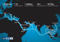 Asia-Africa-Europe-1 – AAE-1 Cable System Lands at Bari in ItalyJuly 2, 2016
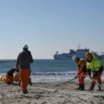 Facebook y Microsoft construirá un Mega-Cable Submarino que unirá España y EE UU y será instalado por la principal operadora española.July 9, 2016
 Why a “Shore-end Cable Installation Package Manager” position is uncommon and unnecessary for Sub Sea Cables Installer companies?July 21, 2016